


You may also like
-
Climatic Chart of the World Poster
Levi Walter Yaggy · 1893 · Educational world climate poster featuring a global map with colorful animal and landscape scenes
Poster from CHF 9 · Framed from CHF 16
Regular price From CHF 6.00Regular price -
Air and Variable winds Poster
James Reynolds · 1854 · Global wind and air current vintage print with elegant arrows across oceans
Poster from CHF 9 · Framed from CHF 16
Regular price From CHF 6.00Regular price -
Annual Rainfall Distribution Poster
Emma Willard · 1954 · Monochrome rainfall map poster with contour bands and crisp scientific typography
Poster from CHF 9 · Framed from CHF 16
Regular price From CHF 6.00Regular price -
Geological map of the world Poster
James Reynolds · 1850 · Detailed world geology vintage print with color-coded strata and neat Victorian labels
Poster from CHF 9 · Framed from CHF 16
Regular price From CHF 6.00Regular price


-

"Very nice Posters. The quality is amazing and we received it very quickly !"
-

"A shop to visit absolutely. Huge selection of posters. We spent more than an hour there !"
-

"Perfect to find gift. Price are very good. An they can frame and pack it on site"


About the Artist
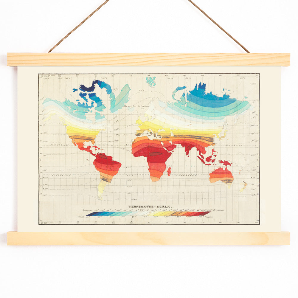
Wilhelm Ebel was active during the mid-19th century, a pivotal era for scientific cartography. This period saw mapmakers transform new scientific measurements into accessible visual formats, as advances in geography, meteorology, and printing converged. Ebel’s contributions reflect a time when maps were valued for both their educational clarity and their decorative appeal.
His name is associated with the meticulous standards of the era, when atlas plates served as both scholarly references and objects of refined taste. Collectors of vintage scientific maps appreciate Ebel’s 1850 work for its blend of precision and curiosity, capturing the spirit of discovery that defined the age.
The Artwork
This temperature world map was created at a time when understanding global climate patterns became increasingly important for science, navigation, and agriculture. Rather than focusing on political boundaries, the map visualizes how temperature varies across continents, making complex data accessible and engaging.
Such thematic maps were widely used in educational settings and private studies, sparking conversations about the natural world. Today, it sits comfortably among other vintage map prints and complements the spirit of inquiry found in the science posters collection.
Style & Characteristics
This vintage print features a global projection organized by temperature zones, with smooth gradient bands that transition from warm to cool hues. The palette includes soft creams, muted blues, gentle yellows, and subtle reds, all set against a light, parchment-like background.
Fine linework and clear typography lend the piece a scholarly, archival feel, while the color gradients add visual interest and clarity. The overall effect is both analytical and inviting, making it suitable as a vintage print for gallery walls or study spaces.
In Interior Design
This temperature map brings a sense of exploration and knowledge to interiors such as home offices, libraries, or living rooms. Its balanced design suits minimalist, modern, and classic spaces, offering a scholarly yet decorative accent.
Pair it with natural materials like wood or linen, and echo its palette with blue accents or warm-toned decor. This world map print is ideal for spaces that value travel, learning, and thoughtful design.