


You may also like
-
World at War Poster
Unknown artist · 1942 · Bold color-coded world map poster charting WWII blocs with crisp labels and legend
Poster from CHF 9 · Framed from CHF 16
Regular price From CHF 6.00Regular price -
Japan the target Poster
Ernest Dudley Chase · 1942 · Dynamic WWII map poster centering Japan with target motif and bold cartographic icons
Poster from CHF 9 · Framed from CHF 16
Regular price From CHF 6.00Regular price -
British Overseas Airways Poster
Seymour E.O. · 1949 · Colorful BOAC world routes poster with sweeping lines across a stylized globe
Poster from CHF 9 · Framed from CHF 16
Regular price From CHF 6.00Regular price -
Army Orientation Course Poster
F.E. Manning · 1940 · WWII instructional poster featuring a globe map and bold Target Berlin motif in blue
Poster from CHF 9 · Framed from CHF 16
Regular price From CHF 6.00Regular price


-

"Very nice Posters. The quality is amazing and we received it very quickly !"
-

"A shop to visit absolutely. Huge selection of posters. We spent more than an hour there !"
-

"Perfect to find gift. Price are very good. An they can frame and pack it on site"


About the Artist
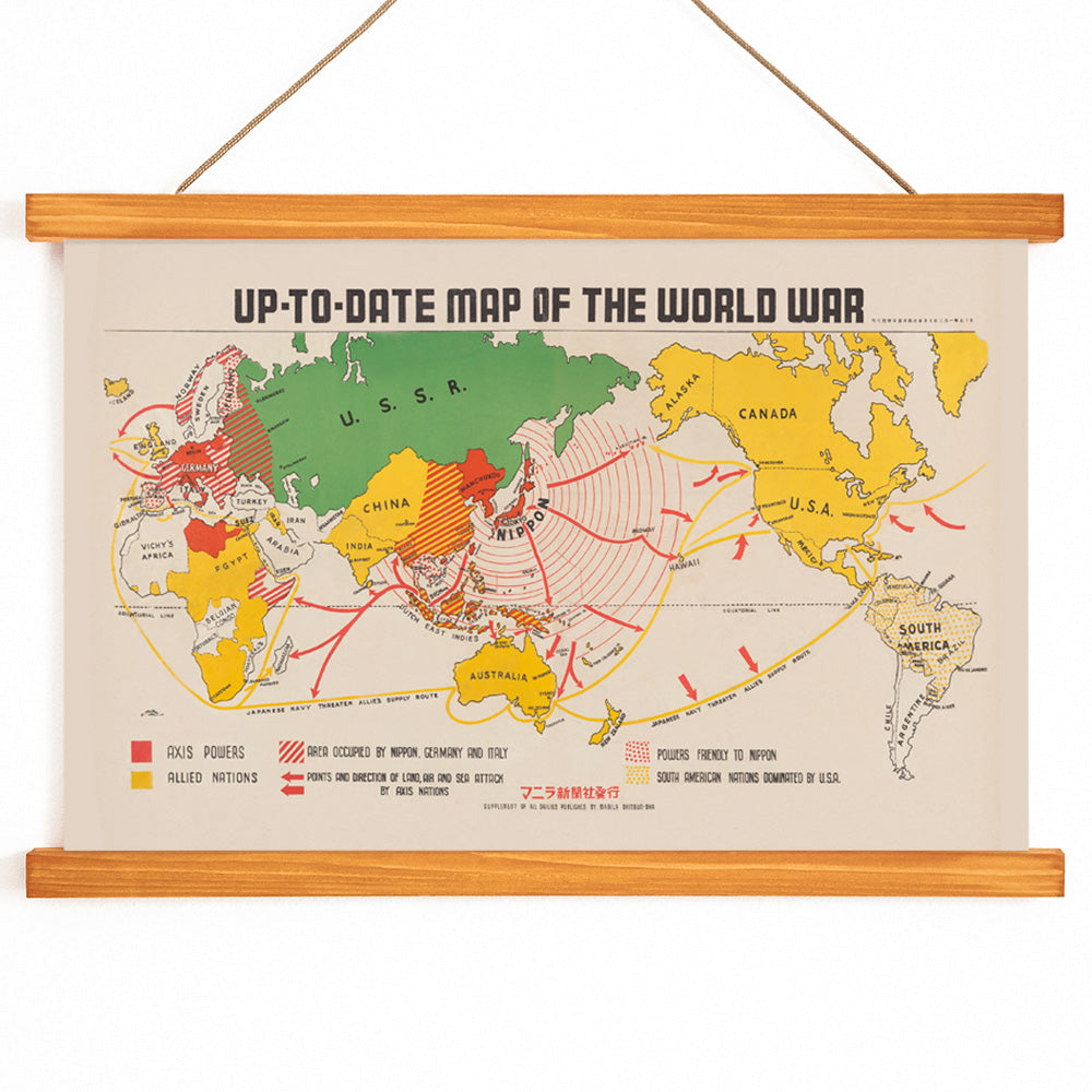
Manila Shinbun-sha was a Japanese-language newspaper publisher active in wartime Manila, serving the Japanese community in the Philippines during the early 1940s. The publisher specialized in newsprint materials that combined reporting with visual aids, reflecting the era’s reliance on maps and infographics to communicate complex events to a broad audience.
This map poster is a testament to the role of journalism in shaping public understanding during World War II. Such works were created not only to inform but also to influence perspectives, providing readers with a visual summary of rapidly changing global events. For historians and collectors, it offers a rare glimpse into how information was curated and disseminated in occupied territories.
The Artwork
Produced in 1942, this world map was designed to help readers track the progress of World War II across continents and oceans. At a time when news traveled slowly, such maps served as essential tools for following military campaigns and understanding the shifting boundaries of conflict. The poster bridges the gap between news reporting and historical record, encapsulating a moment when geography and current events were deeply intertwined.
As a product of its time, the map reflects both the urgency and the limitations of wartime journalism. Its presence today invites reflection on how visual media shaped perceptions of the world during periods of upheaval.
Style & Characteristics
The map features a dynamic composition, with hand-drawn illustrations and bold graphic routes that traverse continents and seas. Distinct color coding—green, yellow, and red—organizes information and highlights key areas of conflict, all set against a warm beige background typical of vintage newsprint.
Clear linework and precise labeling ensure legibility, while animated icons and directional arrows add movement and immediacy. The overall effect is documentary and energetic, characteristic of mid-century news graphics, making it an engaging choice for those drawn to historical cartography and visual storytelling.
In Interior Design
This vintage map poster is well suited to studies, offices, libraries, or hallways where its historical narrative can be appreciated up close. It pairs beautifully with dark woods, leather, and metal, and complements both eclectic and modern interiors.
For a curated display, combine it with other vintage map posters or include it in horizontal wall art arrangements. Its beige tones also harmonize with linen and green-themed decor, creating a calm, archival atmosphere.